Coastal Flooding Community Science
Working with local residents to prioritize resilience actions.
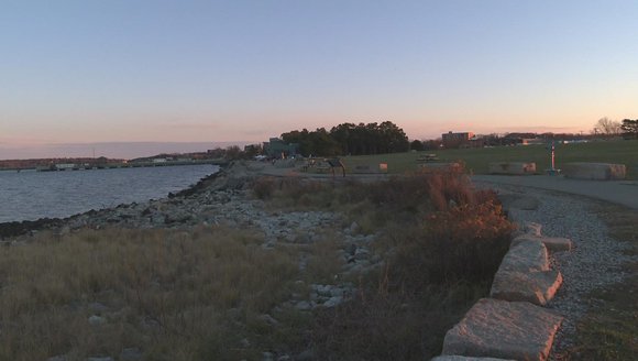
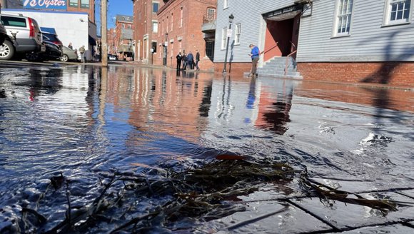
Our coastal flooding community science project provides guidance on how to contribute observations that will help pinpoint high-risk flooding areas in your community. Community members can identify the weather and water level conditions during flooding events, and describe how the flood impacts their community. Collectively, these data will inform future decisions that will prioritize community resilience.
Project Goals:
- Collect data that reveals the weather and sea conditions associated with localized coastal flooding.
- Inform community actions by methodically gathering residents’ opinions on relative site values and impact concerns.
- Raise community awareness among residents about local flooding impacts.
- Create a region-wide protocol and network for sharing flood impacts to ensure communities better understand their unique risks and can identify priorities for building resilience.
Coastal towns and cities will face major challenges as they prepare for sea level rise and the increase in storm intensity and frequency that we are already beginning to witness as a result of climate change. These municipalities face two critical obstacles:
- Difficulty in obtaining or accessing scientific information at a level of detail necessary to assess the relative vulnerability of municipal assets and coastal businesses.
- Low rates of engagement and understanding on the part of taxpayers and residents.
Contribute Local Data
Learn how you can contribute local data to support specific coastal community resilience planning in Belfast, Portland, and South Portland, as well general planning efforts anywhere along the coast by visiting this project on the Ecosystem Investigation Network page.
In the news

Monitoring coastal flooding in Maine
newscentermaine.com|Feb 10, 2021
To address these challenges, we developed a community science project to guide residents toward contributing observations that will serve to formalize local knowledge of what conditions lead to flooding, erosion, and splash-over in their regions. Weather stations and a water level loggers in towns are used to collect local weather and sea level data to correlate with community members’ observations to identify patterns of precipitation, wind, and astronomical tides that lead to problematic local high-water events, as well as where these impacts will most frequently occur. This information will inform and prioritize future action, including infrastructure investments or relocation.
Project Team
Read More
-
![Maine coastal areas plan natural solutions to reduce flood impacts from climate change]()
Maine coastal areas plan natural solutions to reduce flood impacts from climate change
Press Clips
-
![Barely a cloud in the sky and Portland, Maine, is flooding]()
Barely a cloud in the sky and Portland, Maine, is flooding
Press Clips
-
![Gulf of Maine, Explained: Sea Level Rise]()
Gulf of Maine, Explained: Sea Level Rise
The Gulf of Maine occupies only a small corner of the global ocean, but it is a microcosm for changes, challenges, and opportunities arising around …
Gulf of Maine, Explained
-
![Public Workshops Explore Sea Level Rise]()
Public Workshops Explore Sea Level Rise
The impacts of climate change are becoming increasingly visible in our state and across the nation. You’ve probably noticed more frequent news coverage of intense …
Tidings