2023 Gulf of Maine Warming Update
Reports | Feb 15, 2024
The Gulf of Maine experienced its fifth-warmest year in 2023, continuing the long-term trend. Sea surface temperature anomalies varied seasonally, with record breaking temperatures in the early part of the year giving way to more mild conditions in fall and winter.

Highlights from Another Remarkably Warm Year
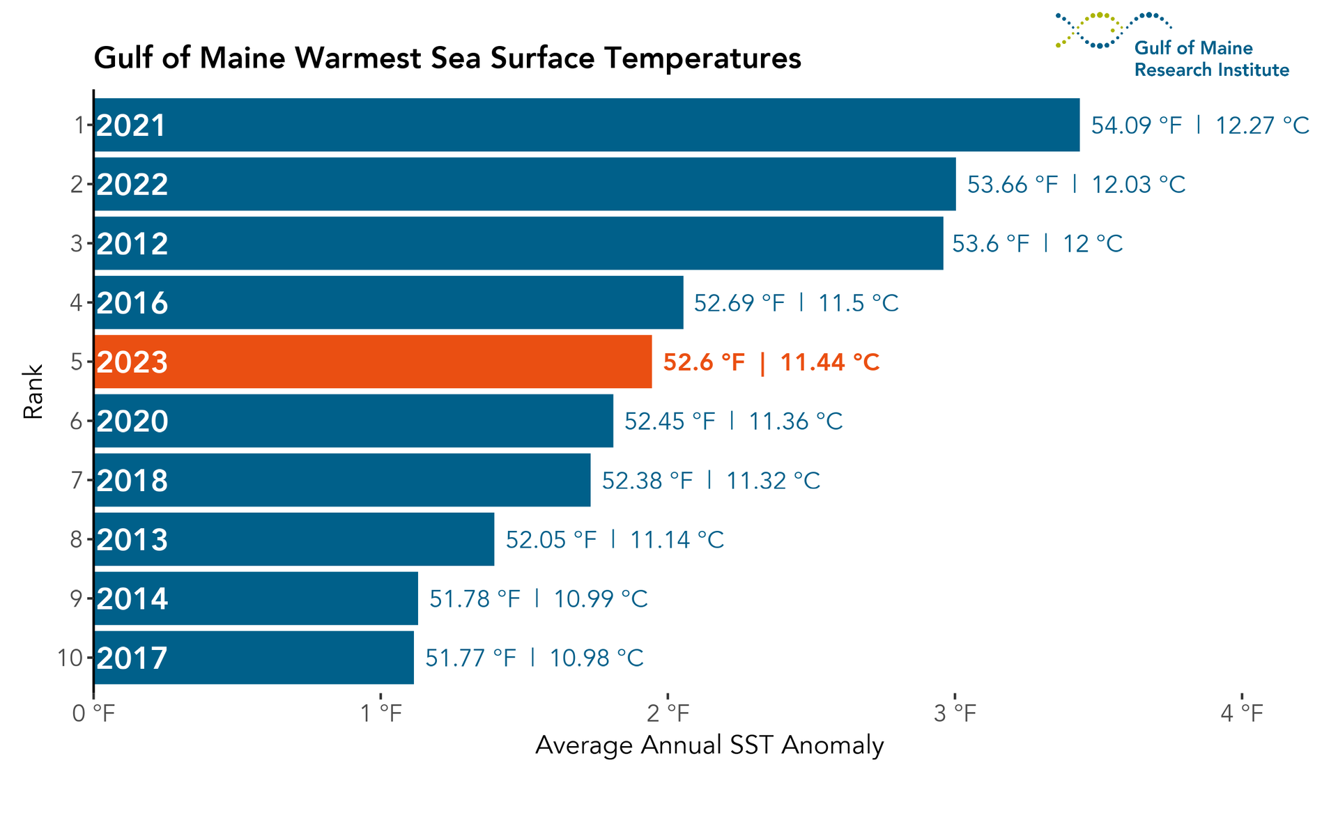
With an annual average sea surface temperature (SST) of 52.6°F — more than 1.9°F above normal — the Gulf of Maine experienced its 5th warmest year on record in 2023. 2021 remains the warmest year on record for the Gulf of Maine (with an average annual SST of 54.1°F), but 2023 was record-breaking by a number of other measures.
For the first four months of 2023, average monthly SST was in the top three warmest over all years on record (i.e., since 1982).
February, March, and April each set new records for highest monthly average SST in the Gulf of Maine.
SST anomalies in the Gulf of Maine returned to levels that were closer to the long-term average in later parts of the year.
SSTs in 2023 were consistent with the long-term trend of increasingly warm conditions driven primarily by anthropogenic climate change.
Annual Warming Rates
Since the early 1980s, the rate of warming in the Gulf of Maine (0.9°F / decade) has been triple that of the world’s oceans (0.3°F / decade, Figure 1). The precise causes of the pronounced jump in annual average SSTs in the region from 2009 to 2012 remains an area of active research, but the sustained warm conditions suggest a shift in the influence of major ocean currents (i.e., Gulf Stream vs. Labrador Current) in the Gulf of Maine. While a long-term increase in SST is expected as a result of human-caused climate change, we also expect each year to be influenced by large-scale patterns of natural variability, particularly on regional scales. In 2023, SST in the Gulf of Maine continued distinguishing the region as one of the fastest warming ocean regions on the planet.

World land and sea surface temperatures in 2023 have been reported as the warmest yearly temperatures on record, with alarmingly high SSTs observed in the North Atlantic. North Atlantic SSTs were on average 1.5°F above the 1991 – 2020 baseline for the year, and on 304 days (83% of the year) daily SST values set record highs (Figure 2). 2023 was decisively the hottest year on record for the region, which added to a pattern of record-breaking temperatures for North Atlantic SST in recent years. As we look back on this pattern, we can see that all daily record SSTs have occurred in recent years: 2020, 2022, and 2023.

2023: SST in the Gulf of Maine
For the Gulf of Maine, 2023 was a relatively cool year when compared to other recent years. The year began with a prolonged period of record setting temperatures, with SSTs exceeding 5°F above the long-term climatological average (Figure 3). Average spring SSTs were the second warmest on record, but by the end of April they were on the decline. A brief spike in SSTs in July would lead to a short period of record setting daily SSTs. The latter half of 2023 would experience conditions much closer to long-term average conditions, with the passage of extratropical storm Lee aiding to keep SSTs low as it traversed through the region.

2023 Ranking
The annual average SST in the Gulf of Maine for 2023 (52.6°F) secured its place as the fifth warmest year on record (Figure 4), propelled by record-breaking warmth to start the year (Figure 3). With the exception of 2015 & 2019 (now ranked 11th & 16th), eight of the past 10 years have been among the top 10 warmest years on record.
Average Monthly Conditions
Monthly average SSTs (Table 1) show how variable conditions were throughout the year. For the first third of the year, monthly SSTs were among the top three warmest for those months. A gradual return to milder conditions began throughout the summer months. This trend continued through the latter half of the year, with no month after July ranking higher than the 12th warmest on record.

2023: Daily SSTs in the Gulf of Maine
The annual cycle of SST in the Gulf of Maine exhibits a pattern common to regions in the Northern Hemisphere, with the lowest temperatures observed in March and the highest values observed in August (Figure 5).

SST Anomalies and Marine Heatwave Events
Daily SST anomalies in 2023 ranged from as low as -1.8°F (below) and as high as +5°F (above) the long-term (1991 – 2020) average. Over the course of the year, the Gulf of Maine experienced three marine heatwave (MHW) events (Figure 5). The first MHW event began in January and continued through May, lasting for a period of 113 days, with an average SST anomaly of 3.7°F. This was the longest MHW event of 2023. Two shorter events occurred previously, one for 16 days in July, and another for six days in September.
Defining Marine Heatwaves
A MHW is commonly defined as an event where daily average SSTs exceed the 90th percentile of a climatological (i.e., 30-year) average for at least five consecutive days. Temperatures falling below this threshold for two days or less do not constitute a break in the MHW event.
Record Setting Daily SSTs in 2023
Daily SST values in the first half of 2023 were some of the highest ever recorded in the Gulf of Maine. In fact, record-breaking warmth was observed on well over half the days in February, March, and April (Figure 6).

Gulf of Maine SSTs in Flux
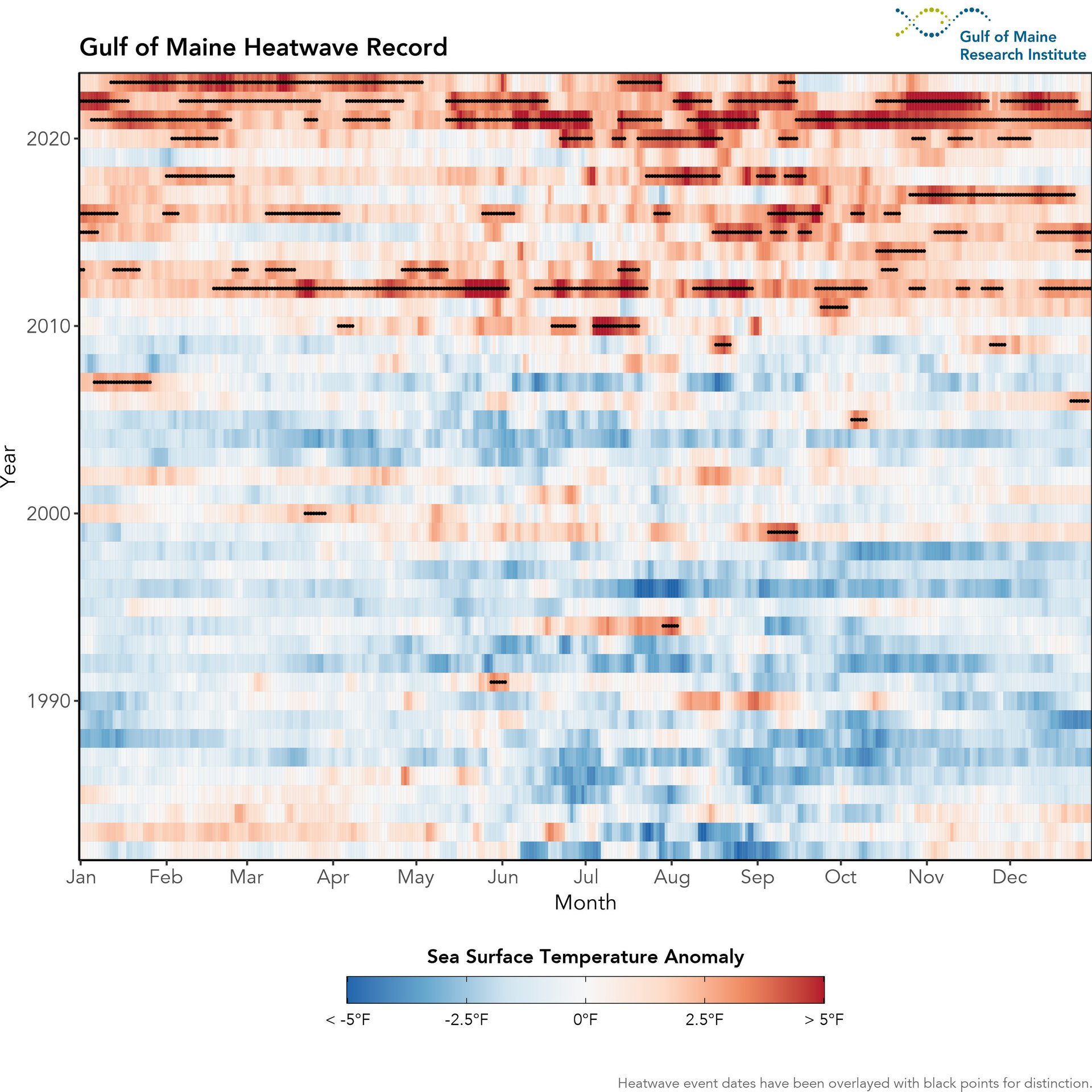
Taken as a whole, the complete picture of conditions for the Gulf of Maine reveal a region experiencing profound changes. Since 2010 the Gulf of Maine has experienced a disproportionate number of anomalously hot SSTs and prolonged MHW events. Cooler than average SSTs have consequently become more rare.
Figure 7 shows how the balance between above (red) and below (blue) average conditions has changed since the 1980s. Since around 2010, SSTs in the Gulf of Maine have been frequently above average, with the region experiencing prolonged MHW events, often in the late summer and fall. The shift of balance between warm and cool days affects warming rates and seasonal trajectories of SST in the Gulf of Maine.
Quarterly Warming Trends
Zooming in to sub-annual timescales reveals some interesting patterns: the observed rate of warming in the Gulf of Maine varies throughout the year. Comparisons across the four quarters of the year (Figure 8) reveal that the Gulf of Maine is warming fastest as much as four times the global average during July-September. This rate of summertime warming is 70% faster than that experienced during April-June.

Annual SST Anomaly Map
In addition to the temporal variability in SST patterns throughout the year, there can also be significant spatial variability in annually-averaged SST patterns. This year, a persistent area of high SST anomalies occurred to the east of the Chesapeake Bay, off the coast of Maryland and Virginia, and situated just beyond the shelf break along the path of the Gulf Stream. Large areas of above average and below average SSTs were situated to the south and east of the Gulf of Maine (Figure 9). In this area, Gulf Stream water interfaces with the Labrador Current. The relative influence of these two major currents creates a dynamic marine environment susceptible to large swings in SST.

Quarterly Average Maps
Looking at spatial patterns in SST anomalies across the annual quarters of 2023 (Figure 10) shows not only the large spatial variability in SST conditions, but also how that spatial variability can vary significantly over the course of the year.

Gulf of Maine vs. Global SSTs in 2023
It was not just the Gulf of Maine that experienced exceptional warmth in 2023. Globally, this past year was the hottest year on record for both SST and combined land & ocean temperatures.
Figure 11 shows annual average SST & SST anomalies globally for 2023; the dominance of pinks and reds throughout the figure illustrates how the vast majority of the world’s ocean surface experienced well above average SSTs. The profound warm anomaly in the Mid-Atlantic stands in stark contrast to more muted anomalies throughout the rest of the global oceans. A notable exception to this is in the eastern equatorial Pacific where quite warm SST anomalies dominate as a result of El Niño.

A Note on Data Sources
The figures in this report are created using remotely-sensed satellite data as part of publicly funded research efforts. Satellite SST data was obtained from NOAA’s National Center for Environmental Information (NCEI), with all maps and figures displaying NOAA’s Optimum Interpolation Sea Surface Temperature Data.
- NOAA High Resolution SST data provided by the NOAA/OAR/ESRL PSL, Boulder, Colorado, USA.
Recommended Citation
Gulf of Maine Research Institute, 2024. 2023 Gulf of Maine Warming Update. https://gmri.org/stories/warming-23
The Gulf of Maine Region
For analyses like these, it is important to be clear about the spatial extent that “defines” the Gulf of Maine (Figure 12), as different borders could produce different results. The spatial domain we use as the “Gulf of Maine” is displayed below. This area is consistent with previous reports and publications GMRI has produced.

Read More
-
![Tremont's Quest for Resilience in a Changing Climate]()
Tremont's Quest for Resilience in a Changing Climate
Read on to learn more about what it takes to ensure coastal communities continue to thrive in a warmer world, and to see the role …
Perspectives
-
![Gulf of Maine, Explained: Storms and Coastal Flooding]()
Gulf of Maine, Explained: Storms and Coastal Flooding
In this edition of Gulf of Maine, Explained, GMRI Postdoctoral Researcher and coastal hazards expert Dr. Hannah Baranes talks about how we can use the …
Gulf of Maine, Explained
-
![2023 Casco Bay Ecosystem Monitoring Report]()
2023 Casco Bay Ecosystem Monitoring Report
Scientists at the Gulf of Maine Research Institute (GMRI) are conducting long-term, nearshore monitoring to learn about the pace and direction of changes in our …
Reports
-
![2023 Research Progress Update]()
2023 Research Progress Update
Each year, to keep you updated on our research team's progress, we develop a report showcasing some of our lab's achievements. More broadly, this report …
Reports


